Hoverla
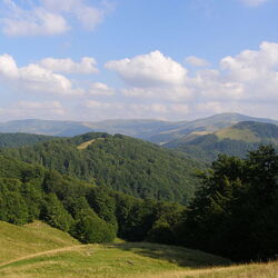
Hoverla is the highest point of Ukraine, located in the Carpathian Mountains near the Romanian border. In cloudless weather, you can see the cities of Snyatin, Ivano-Frankivsk, and Sighetu-Marmara from the top of the mountain.

The top of the mountain is located at an altitude of 2,061 meters. The Prut River originates at the very foot of the mountain. There is a very beautiful fairy tale about the origin of the river and the mountain. Once upon a time there was a girl named Hoverla, and she loved the young man Prut very much, but her father, Molfar, was against their relationship. And then he turned his daughter into a huge mountain to hide her. Rod found out about this, but in order to disenchant the girl, he had to climb the mountain at dawn, but he was too late and then sat on the top and began to cry. And he cried for so long that his tears became a river, and now Prut and Hoverla are forever inseparable. Falling down the mountain, the river forms a mass of small waterfalls, with a total height of 80 meters.
Goverla Mountain is very popular among tourists. The first trail for travelers was opened back in 1880. Almost all ascents of the mountain begin from Zaroslyak, a base located at an altitude of 1100 meters. Getting to it is quite simple, if desired, you can even get there by car or bike. There are 2 trails leading from the base to the top of the mountain: a shallow (4.3 km) and steep (3.7 km), but even a walk along a steep path in the summer can be overcome by any unprepared tourist. You can stay at the base for the night, its rooms are designed for 100 people, some spend the night right in tents.

You can get to the base from the villages of Kvasy, Vorokhta, Ust-Goverla, Yasinya, Lazeschina. There is a checkpoint in front of the mountain, where everyone who enters is recorded and a cash fee is collected. To climb Hoverla, you need to take comfortable shoes and ski poles for a comfortable ascent. The only danger on the mountain is the weather, as the temperature at the top is 6-8 degrees lower. There is a marble slab at the top of the mountain, which contains land from 25 Ukrainian regions. You can also see a flagpole with the flag of Ukraine and a huge obelisk marking the border between Czechoslovakia and Poland, which once passed through here.