Mount Makalu
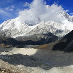
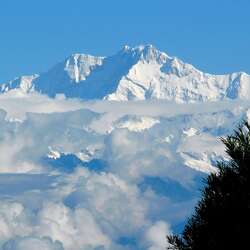
The peak of Mount Makalu, whose name translates as "Black Mountain", is considered the fifth highest in the world. Because of the steep slopes and narrow ridges, it is recognized as the most difficult for the conquerors of the difficult peaks. Statistics show that less than 30% of expeditions achieve success. To date, 17 routes have been laid. The height of the aspiring peak is 8,463 meters.

A few facts about Mount Makalu
The unique elevation is located in the Himalayas, it is located partly on the territories of Nepal and China, belongs to the Mahalangur-Himal mountain system. Mount Makalu is surrounded by the Sabha River from the south, bordered by Mount Everest from the west. It is bordered by the Arun River from the east and China from the north.
Important facts:

- A unique pyramidal vertex with four edges. There is a national park nearby.
- Due to the very steep slopes, the snow cover does not linger at the top of Mount Makalu, so from a distance it appears black. That's why the locals gave it that name.
- In the winter period from December 29, 2008 to February 14, 2009, climbers Denis Urubko and Simone Moro conquered Makala.
The peak attracts the bravest and most desperate climbers. However, as history shows, many conquerors died or disappeared without a trace.
Features of Makalu Peak
The territory of Mount Makalu is divided into several natural areas. The river valley stretches to the 1 kilometer mark, after which an area of tropical forests appears. Dipterocarp forests also originate here. Coniferous vegetation grows from the 2.5 km mark. The height of 4 kilometers is the realm of fabulous alpine meadows.
Hard-to-reach places of glaciers and stone zones start at the 5 kilometer mark. The Himalayas are famous for their harsh climate. In winter, the temperature drops to -40 degrees, and in summer - to -25 degrees. The ascent is hampered by hurricane-force winds, which reach speeds of up to 150 km/h.
Protected area
In the vicinity of the hill is the Makalu-Barun National Park. This is one of the parts of another protected area of Sagarmatha. The area is 1,148 km2 and belongs to the Sacred Himalayan Landscape natural area. There are also Chamlang peaks (7321 m) and 6476 m high next to the national park.
Travelers are attracted by the beautiful alpine meadows. The national park is home to 40 species of bamboo, 50 varieties of orchids, and primroses. The symbol of the country is the magnificent rhododendron, which can be found everywhere in protected areas.
Various forests are home to predators, herbivores, and hundreds of butterflies. A rare animal lives here - the Temminka cat. The animal is considered a descendant of Kalimantan cats. The average length of the animal from the nose to the tip of the tail is on average 95 centimeters. A mysterious place on earth, Mount Makalu attracts travelers every year with its legends and pristine nature.