Watnayokudl National Park
Vatnajokull is the largest national park in Iceland, as well as in the whole of Europe. Its area is 12,000 km2 - almost 12% of Iceland's territory. The park was founded on June 7, 2008 and includes the former national parks Skaftafetl, founded in 1967, and Yekulsaurgluvur, founded in 1973. By its area, it is the largest national park in Europe. The huge Vatnajokull glacier, which occupies an eighth of the area of Iceland, is located on the territory of the park. Not all the infrastructure has been built yet, but the park already attracts quite a lot of tourists every year.

Yekulsaurgluvur National Park
Yekulsaurgluvur is located in the north of Iceland near the Yekulsau au Fjedlum River, near the famous Dettifoss waterfall. More than 8 thousand years ago, a volcano formed under the river, and after a powerful eruption, the area changed dramatically and an area was formed that is now called Yekulsaurgluvur. In the center is the Echo Rock. The most beautiful mountain is Red Mountain, so named because of its high iron content, which gives the mountain a red hue. Of the attractions, it is worth highlighting the Ausbirgi Canyon, the northern part of which looks like a horse shoe.
Skaftafetl National Park
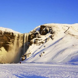
On the territory of Skaftafetl there is the Morsardalur valley, Kristinartindar Mountain, Skaftafetlskull glacier, as well as the Lucky volcano. During the eruption of Mount Lucky in 1783, more than 50% of Iceland's livestock and almost all birds died from toxic fumes. The length of the lava flow was more than 130 km, the lava bay covered an area of 560 km2. The melted snow caused terrible floods, and famine destroyed 20% of the country's inhabitants. This eruption is considered one of the most devastating in the history of the Earth, the rising ash delayed the sun's rays, which led to a drop in temperature and crop failures next year in Europe.

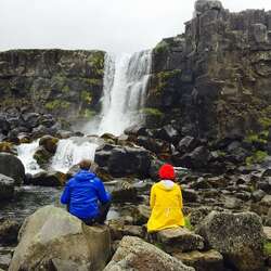
The relief of the Vatnajokull Park is similar to the Alpine one, which was formed over the millennia by the Eryvajokull volcano, the Skaftafetlskull and Skeidarajokull glaciers. And the eruptions under the ice cover were caused by glacial flows that raised the water level in the Skeidar River. The climate in this area is milder than in the rest of Iceland, and there are even more sunny days here, which is unusual for southern Iceland. The Svartifoss waterfall (Black Waterfall), which is 12 meters high, is located in the Vatnajokull National Park. The waterfall consists of hexagonal columns of black lava, which is how its name originated. The columns appeared in the lava flow, slowly cooling and crystallizing. Something similar can be seen in Ireland, in a place called the Road of the Giants and also on the Scottish island of Staffa. These basalt columns inspired many Icelandic architects to create wonderful masterpieces of classical architecture, and the most notable of them are the Hallgrimur Church in Reykjavik and the National Theater.
In the Middle Ages, there were several large farms in Vatnajokull Park, but due to volcanoes and floods, farmers had to leave these places. But now you can see 2 parks here, where income comes mainly from tourists.
With an area of 8,100 km2, the Vatnajokull Glacier is the largest glacier in Europe. the thickness of the ice reaches up to 1 km, and on average 400-500 meters. There are 7 active volcanoes and ice caves under the ice of the glacier. The Eryvayekull volcano has a crater caldera of 20 km 2, Grimsvetn - 100 km 2, Bardarbunga - 60 km 2. Lakes are also hidden under the ice, which are formed as a result of volcanoes, lakes sometimes lead to major floods.
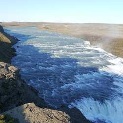
The glacier has been studied by scientists for a long time, which led to the fact that in 2008 the area was declared a national park. The Jekulsau au Fjedlum River is born in the Vatnajokull ice, forming the largest waterfall in Europe, Dettifoss. The region is quite popular, with snowmobiling and skiing, as well as hiking.