Shiretoko National Park
Shiretoko National Park is a peninsula in the east of the Japanese island of Hokkaido. The name of the peninsula comes from the language of the Ainu people and means "the edge of the earth." Kunashir Island is clearly visible from the eastern tip of the peninsula. It is one of the least populated and cultivated areas of Japan.

The excellent preservation of wildlife in Siretoko National Park allowed UNESCO to add it to the World Heritage List in 2005. At the same time, a wish was expressed to expand the area of the protected facility by adding the territory of a number of Kuril Islands and converting the facility into a joint Russian-Japanese Peace Park.
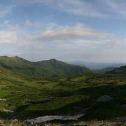
The Siretoko Peninsula is quite narrow and long. Its pride is considered to be the Rausudake Peak, towering 1,661 meters above sea level and Io volcano. In addition, the shores of the peninsula rise above the Sea of Okhotsk by more than a hundred meters, which is why every tourist has the opportunity to admire the small and large waterfalls, whose waters fall directly into the sea, and to follow the colonies of numerous birds.

Another attraction of Siretoko Park, which attracts a huge number of tourists here, is that the age of the forests located on the peninsula defies any calculation. There is a long-standing belief among locals that these trees have always been here: they stand in a fairly dense wall, through which only the local population, who know the area well, can squeeze through.
At the entrance to Siretoko, each tourist is given a can of special "bear gas" and is advised to make as much noise as possible, stay in a group, ring various bells and not stray from the hiking trail. Otherwise, as it says on one of the local posters, the probability of death will increase to almost 100%.
The most accessible and popular place to visit in Siretoko is the Five Lakes. Probably a very beautiful natural place. Alas, a road was built to it for tourist buses, only two of the five lakes are open (the rest are closed due to the fact that bears were spotted there), and such groups of tourists are constantly walking along the paths along these two lakes. Kamuiwakka waterfall falls directly into the sea. Kamuiwakka in the Ainu language means the river of the gods. An 11-kilometer road has been laid to the river through the forest, after which it takes half an hour to walk along the bottom of the sulfur river to a hot waterfall. Moreover, the closer to the waterfall, the warmer the water becomes. They say. The top hottest waterfall is forbidden to visit because of the stones falling from it. Walking on the river is also scary for all Japanese travel guides – it's easy to slip, scratch, the wound will hurt from sulfur, and there is no ambulance or cellular service.