National Park Death Valley
Death Valley is a national park in the United States, covering an area of 13,518 km2. The National Park contains 3 huge valleys: Salina, Panamint and Death Valley. It has the driest climate of any national park in the United States.

Before the formation of the national park, gold mining was mainly carried out here. The first Europeans visited here in 1849, when they were looking for a shortcut to the gold mines in California. They wandered here for almost a month and lost a traveling companion, eventually they decided to name this place Death Valley. At the end of the 19th century, settlements arose here, the population of which was engaged in gold mining. But the gold reserves ran out and the settlers fled, only one thing brought income here - mining borax, which was used to make soap and not only. The ore wagon was transported by 18 mules and 2 horses. In 1993, it was decided to form the Death Valley National monument here, and a year later it was transformed into a national park.
The landscapes of Death Valley Park are very ancient and began to form almost 2 billion years ago. Once there was a warm shallow sea lapping here, as evidenced by marine sediments. But due to the movements of the earth's crust, a crevice appeared and almost all the water went into the Pacific Ocean. Later, due to the same movements of the crust, mountains began to grow here, blocking the channel to the ocean.

About 9,000 years ago, the Nevares Spring Indian tribe lived here, which was engaged in hunting and gathering. Back then, Panamint and Menley Lakes could be observed in Death Valley, and the climate was better and there was an abundance of birds. About five thousand years ago, these places were inhabited by the Mesquite Flat culture. 2000 years ago, the Saratoga Spring Indians came to these places, the climate then was about the same as it is today - a dry and arid desert.
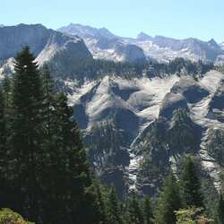
Telescope Peak is the highest point of the park, with a height of 3,368 meters. In general, there are 5 mountain ranges in Death Valley that block the path of humid air. The air masses descending from the mountains heat up strongly and the moisture in them evaporates, because only dry air masses reach the ground, a similar phenomenon climatologists have called "rain shadow". Therefore, this area is the driest in North America, with no more than 50 mm of precipitation per year, and precipitation in the mountains reaches 400 mm. When the rain masses pass through the mountains, they usually cause heavy downpours, forming seasonal lakes.
In Death Valley, the animals adapted to the dry climate. Among the indigenous inhabitants, you can meet bighorn sheep, coyotes, and three-pronged larreys. More than 90% of the park is considered wild and completely uninhabited.
The park is known for its unexplained phenomenon of moving rocks in the dried-up Raystack Playa Lake in Death Valley. The movement of the stones is indicated by the footprints following them. The boulders move on their own without the help of people, but no one has been watching them for a long time on camera. The boulders fell to the bottom of the lake from a hillock, which is 260 meters high, and the weight of individual stones reaches a hundred kilograms. The trail following them has a length of a couple of tens of meters. The most mysterious thing is that the stones move once every few years, and sometimes they turn over. Scientists believe that in order for them to move the stones, several conditions must be met: a small layer of clay with a layer of ice and strong winds to turn the stone over. But there is no explicit theory explaining such spontaneous behavior of stones. After all, the stones are moving in different directions, and some of the stones nearby are standing still. In addition, strong winds rolled stones from one shore of the dried-up lake to the other, but the stones are scattered chaotically.