Chusovaya
The Chusovaya is one of the most beautiful rivers in Russia, originating in the Urals and flowing into the Kama River. The picturesque shores, as well as the frequent mention in the literature, have made Chusovaya a popular tourist destination.

The origin of the river's name
There are several versions about the origin of the river's name. One of them has a name consisting of two words "chus" and "va", which are translated from the Permian Komi language as a fast river. Today, the local peoples do not have the word chus, but the names of the Poludenny and Severny Chus rivers have been preserved in the Permian Komi District. Therefore, the name of the Chusova River (Chusva) was distorted into Chusovaya. According to another version, in the 3rd century, the Hun tribe migrated from the Irtysh to the Semirechye and founded the Chuban state between the Ili and Chu rivers. Later, some of the "Chui tribes" went to the Urals and joined the Bashkirs, and in memory of their lands they named the Chu River. "Chu-suv" is translated from Bashkir as "Chu River".
The length of the river is 593 kilometers, over which it crosses the Chelyabinsk and Sverdlovsk regions and the Perm Territory. In total, more than 150 rivers flow into the river, of which the most abundant are: Bolshoy Shishim, Usva, Serebryanskaya, Revda, Shaitanka, Koiva. During floods, the water rises by 4-5 meters, while in August the river becomes very shallow and the water sometimes does not exceed the water level of 15 cm. The bottom of the river is rocky and there are about 70 rifts along its entire length, which makes it a very popular place for rafting. The locals call the rifts too much, among them the biggest Kashkinsky bust. The river banks are mostly flat, but there are steep cliffs, in some places the rocks stand on the riverbed. Such rocks are called "fighters" and the most dangerous ones have their own names. At first, rafting on the river was extremely dangerous. In 1877 alone, 23 ships crashed on the Robber rock, and more than a hundred people sank with them. Because of this, work had to be carried out to improve navigation conditions: the most dangerous rocks were blown up, large stones were removed from the slopes, and logs were installed near the rocks to soften the impact. These measures have reduced the number of wrecks from 10% to 4% of the total number of ships that sailed.

Along the banks of the Chusovaya River, you can see a wide variety of animals and birds. These are moose, wolves, bears, hares, beavers, squirrels, chipmunks, muskrats, geese, ducks, grouse. All this is due to the variety of natural landscapes from swamps and meadows to coniferous and deciduous forests. In the river itself, you can easily catch crayfish, pike, perch, yazia, bream, ruff, minnow, roach.
River tourism
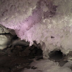
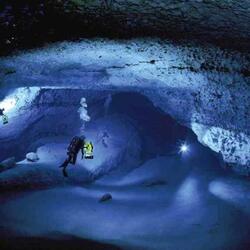
During the Soviet era, tourism was actively developing on the river. To do this, in the 1960s, they developed an all-Union route for tourists from the village of Sloboda to the city of Chusovaya, which was serviced by the Kourovskaya campsite (renamed Chusovaya in 1987). At that time, up to 3,000 tourists were rafting on the river. You can go rafting on the river in April after the ice breaks. Rafting on the river is safe, only fighter rocks can pose a danger, but they are not terrible for light catamarans. In 1980, plaques with their names and descriptions were placed near such rocks. Many of them are listed as natural monuments and are under protection, and some of the stones have caves. Filin Rock is of historical value, and parts of ceramic dishes dating back to 1000 BC have been found in its cave.