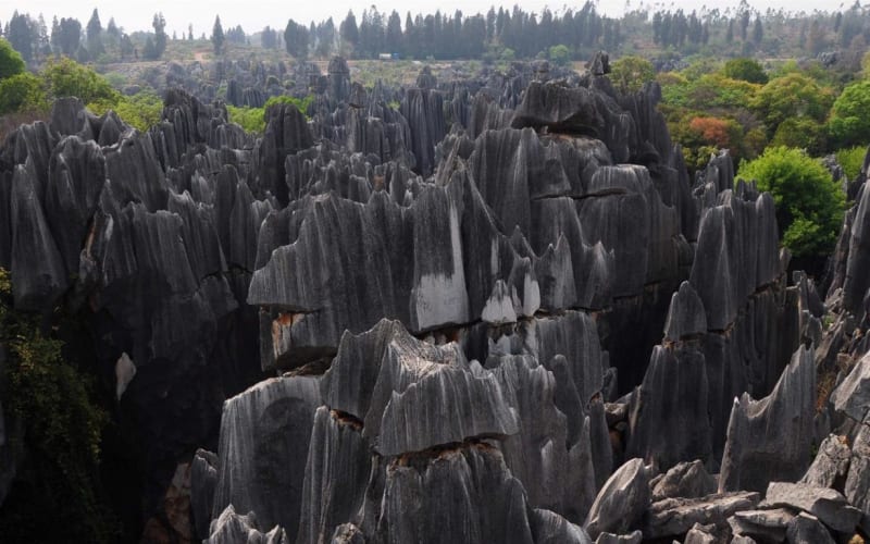

Tsingy de Bemaraha is one of Madagascar’s most extraordinary natural landscapes, famous for its sharp limestone rocks, deep gorges, and forests growing among stone pinnacles. This natural complex lies in the western part of the island and is striking for its contrast between grey rock formations and dense greenery. Its name comes from the Malagasy word “tsingy,” used to describe rugged stone labyrinths with sharp projections.
The defining feature of the area is its vast field of limestone needles and towers, shaped by prolonged erosion. Some vertical pinnacles rise to around 100 metres. Narrow fissures, gorges, and natural corridors run between them, creating the impression of a forest made of stone. Such terrain occurs in few places around the world, making Tsingy de Bemaraha one of Madagascar’s most important geological treasures.
How the stone forest formed
Millions of years ago, limestone layers formed in an ancient marine environment. Later changes in sea level and movements of the Earth’s crust exposed them above ground. Rainwater gradually dissolved the limestone, widened cracks, and washed away softer sections of rock. Over time, a complex karst landscape developed, with sharp peaks, deep crevices, and underground cavities.
In places, the formations resemble Gothic cathedrals, stone teeth, or endless rows of needles. From above, they look like a grey labyrinth cut through by green strips of forest. The scenery is especially dramatic in angled sunlight, when shadows emphasize the depth of the fissures and the texture of each rock face.
National park and protected area
Tsingy de Bemaraha National Park protects unique limestone formations and natural ecosystems in western Madagascar. Nearby is a strict nature reserve that gained international recognition for its exceptional geology and rich wildlife. The reserve was inscribed on the UNESCO World Heritage List in 1990; in 2023, the boundaries of the heritage property were expanded and it was renamed the Andrefana Dry Forests.
The area contains dry deciduous forests, savanna, bodies of water, and other natural habitats. These environments support many plant and animal species characteristic of Madagascar. The island’s isolation over millions of years has led to a high number of endemic species–organisms found nowhere else in the wild.
Wildlife and vegetation
The rocky labyrinths and surrounding forests provide refuge for lemurs, birds, reptiles, and other animals. Visitors may encounter sifakas moving skillfully between stone projections, as well as numerous chameleon species and other endemic reptiles. Some animals have adapted to life on steep limestone slopes and use narrow fissures as shelter.
Vegetation varies with the terrain and the availability of moisture. Small patches of soil remain in rock cracks, allowing shrubs, vines, and trees to take root. Dry tropical forests grow in wider valleys. This combination of microhabitats supports a remarkable diversity of species within a relatively small area.
Grand Tsingy and Petit Tsingy
The park’s best-known areas include Grand Tsingy and Petit Tsingy. Petit Tsingy is suitable for discovering the unusual terrain on established walking routes. Grand Tsingy features larger rock labyrinths and more challenging sections where bridges, ladders, safety equipment, and a qualified guide may be required.
Trails pass through narrow passages between limestone walls, across forested sections, and above deep crevices. Some routes include suspension bridges offering striking views of the stone pinnacles. Available trails and access conditions depend on the season, trail conditions, and park regulations.
The Manambolo River Canyon
Another important natural attraction in the region is the Manambolo River Canyon. The river has cut through the limestone plateau, forming a deep gorge with sheer walls and patches of forest along the water. From a boat, visitors can view the cliffs from a different angle, see vegetation on the slopes, and appreciate the scale of the geological formations. River trips are often combined with visits to other natural sites in the region.
Best time to visit Tsingy de Bemaraha
Travellers generally choose the dry season, which runs mainly from May to October. Roads and walking routes are usually more accessible during this period than in the rainy season. Heavy rainfall during wetter months can make travel difficult, and some parts of the park may close temporarily. Check local conditions and route availability before travelling.
Getting there and practical advice
Morondava, on Madagascar’s western coast, is one of the usual starting points for a visit. From there, travellers head towards Bekopaka, near the park’s main visitor routes. The journey can take considerable time, depending on the season, the condition of unpaved roads, river crossings, and transport. Visits to Tsingy de Bemaraha are therefore usually planned in advance and often form part of a multi-day itinerary.
Wear sturdy shoes with good grip, bring sun protection, and carry enough water. The limestone projections are extremely sharp, and some trails run along narrow ledges and steep ladders. On challenging routes, use safety equipment and travel with a local guide. Follow the rules of the protected area, avoid damaging rocks and plants, and do not disturb wildlife.
Tsingy de Bemaraha is a place where the geology, plant life, and evolution of Madagascar are revealed in a remarkable landscape. Sharp limestone pinnacles, green forests, and deep gorges make this region one of the island’s most memorable natural attractions.
Gallery