Katavi National Park
Katawi is a national park of Tanzania in the Rukwa region, founded in 1974. Almost all of the park's land is located in the Rukwa rift plain, which is part of the East African Rift System. Lake Rukva in the southeastern part is considered the lowest point of the plain. The main reliefs of the park are the bottom of the rift plain and the mountain hills on two sides of it: in the western part lies Llamba La Mfipa escarpment, in the eastern Mlele escarpment.

Earlier in 1911, the land of Katavi Park was a German colony and was the hunting grounds of Otto von Bismarck. After that, the area passed to Great Britain and until 1932 had the name "Rukva Reserve". The national park was declared here only in 1974, giving an area of 2,253 km2, in subsequent years the park's lands increased and now amount to 25,000 km2. Thus, Katawi is the third largest national park in Tanzania.
According to the legend of the local Band tribe, near the Katavi Lake, the Katavi spirit dwells near the twin trees of the Indian date and false acacia. The name of the locality originated from the name of the spirit.

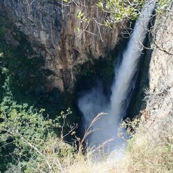
The relief of Katavi consists of a terrace with seasonal lakes, rivers, flooded fields, located at an elevation of 820 to 960 meters above sea level. On the east side, in the steep and rocky escarpment, there are seasonal and permanent waterfalls, such as Chorangwa, Ndido, Lukima. In the western escarpment, you can encounter mountains up to one and a half kilometers high. Almost all the rivers in Katavi Park drain into Lake Rukwa. The main river in the park is Katuma, which feeds Lake Katavi, Lake Chad and the Katisunga meadows, which are flooded over an area of 425 km2 during the rains, also play an important role for the ecosystem. Recently, illegal dams have been erected on the Kapapa and Ngolima rivers, which is why these rivers dry up earlier than usual, causing huge damage to nature. Lake Tanganyika and the Mahale Mountains and Gombe Stream National Parks are located to the west of the park, Lake Nyasa is to the south and Kitulo and Ruaha National Parks lie to the east.
More than 50 representatives of mammals live in Katavi. There are a huge number of animals in the park: zebras - 20,000 specimens, topi antelope - 17,500, buffaloes - 16,000, impalas - 15,000. There are also almost 3,000 elephants, 4,000 hippos, 5,000 wild boars and 4,300 giraffes in the park. With such an abundance of food, lions, hyenas, leopards, and crocodiles feel at ease.
The flora of the park is represented by 226 varieties of trees flooded by meadows. In the lowlands of the park, grassy vegetation mainly collides, trees have settled on the hills, the lowlands are almost always flooded during the rainy season, and they also have the most fertile soil in the park. Mostly white acadia grows near Lake Katava, while mixed forests dominate the escarpments.
Nowadays, the ecological situation in the park is tense. This is due to the fact that farmers are changing hoes for more modern means of cultivating the land, and the increasing number of livestock leads to soil degradation.