Port Campbell National Park
Port Campbell is a national park located 190 km southwest of Melbourne. The special feature of this national park is its coastline. There are bizarrely shaped rocky islets in the form of pillars, wedges, grottoes, chimneys and arches scattered along the entire coast for hundreds of kilometers. But the most picturesque place in the national park is a place called the Twelve Apostles.

The attractions of the Port Campbell National Park include: Loch Ard Gorge (the place is named after the ship Loch Ard, which was wrecked on June 1, 1878. Of the 53 people on the ship, only two survived), the Gibson Steps, the London Arch, the Grotto Rock. They are also a symbol of the "Great Ocean Way". It is worth seeing the "thundering" cave, where the sea rushes in with a roar, and the beach between the rocks, which is nicknamed the "death's head". The beach is known for the fact that sometimes you can see a river flowing into the sea, as well as for its unusual landscape.
The rocks of Port Campbell consist of limestone formed 26 million years ago, when the entire area was under water. As marine animals died, millions of tiny skeletons rich in calcium accumulated on the seabed. Gradually, a layer of limestone up to 260 m thick formed on top of the soft clay. About 20,000 years ago, during the last glaciation, the sea level dropped and the rocks came to the surface. Wind, rain, and waves pounced on the soft cliffs, and for many centuries, every 20-30 years, a piece of rock broke off and fell into the ocean. In some places, the coastline receded evenly, leaving no signs of its former shape, but in other places, softer areas collapsed earlier, and the pillars and arches that we see today appeared.

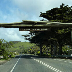
The path to the Twelve Apostles runs along the picturesque coast of the Indian Ocean, which has long been favored by locals and tourists, and which is called the Great Ocean Road. This is one of their most beautiful coastal roads – magnificent views of the ocean, quiet towns on the shore and fishing villages. A large ocean road runs between beautiful cliffs, past waterfalls, through a tropical forest; from here you can enjoy amazing views of the sea and sunken ships. One of the most impressive stretches of the route is the Port Campbell National Park. The Twelve Apostles greatly interfere with navigation, which is why the area is also called the "Island of Lost Ships." At first, the place was called "Pig and Piglets", which in the 1950s was renamed "The Twelve Apostles" in order to attract tourists, despite the fact that there were only 9 rocks in the group. Currently, there are 8 rocks left, as one of them collapsed in 2005, unable to withstand the effects of erosion and wave impacts.
In the park Port Campbell is raging with waves up to 40 meters, which knock out ledges in the limestone at a height of up to 60 m above the tide point. The opening located near the Thunder Cave shows how the sea breaks through soft rocks onto land. Here, the water thunders underground in a 400-meter tunnel made by waves in the rocks. In places, the roof of the tunnel has collapsed, and through the vents you can see the boiling water below.
The London Arch, a rock formation about 20 million years old, exposed to the constant effects of ocean waves, gradually took the form of a two-span bridge. Since there was a noticeable resemblance to the famous London Bridge, this stone formation received the same name. On January 15, 1990, the span closer to the shore collapsed. Two tourists who were at that moment on the far side of the "bridge" were trapped and were soon rescued by helicopter, no one was injured. After the collapse, the London Bridge turned into the London Arch.
The picturesque cliffs of Port Campbell attract not only numerous tourists. Birds such as the slender-billed petrel also come here. They breed on the rocky ledges of the largest cliff, Matton Bird Island, arriving here in late September from Siberia. To do this, they travel 14,400 km across the Pacific Ocean. On the island, the nests are located in close proximity to each other, using any suitable crack. At an unattainable height, birds can raise chicks without fear of humans or rats. Other birds — albatrosses, boobies, cormorants and petrels — also flock to feast. In winter, southern whales swim past these shores on their way from Antarctica to the breeding grounds in the Great Australian Bight. Some linger to breed, but most of the whales, which reach 15 m in length, pass further along the coast without fear of rough waves and rocks.